- Start
- Philip's Handy Road Atlas France, Belgium and The Netherlands
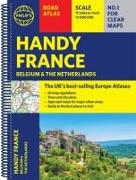
Philip's Handy Road Atlas France, Belgium and The Netherlands
Angebote / Angebote:
Philip's Handy Road Atlas of France, Belgium and The Netherlands features new digital cartography from Philip's - voted Britain's clearest and most detailed European mapping in an independent consumer survey. This compact A5 atlas with lie-flat binding is perfect for travelling across France and the surrounding countries.
Lieferbar in ca. 10-20 Arbeitstagen
Preis
14,90 CHFVerfügbarkeit:
LieferbarArtikel, die Sie kürzlich angesehen haben

Fremdlagertitel. Lieferzeit unbestimmt