- Start
- Rand McNally Folded Map: Sacramento Street Map
Rand McNally Folded Map: Sacramento Street Map
Angebote / Angebote:
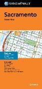
Rand McNally's folded map for Sacramento is a must-have for anyone traveling in and around this part of California, offering unbeatable accuracy and reliability at a great price. Our trusted cartography shows all Interstate, U.S., state, and county highways, along with clearly indicated parks, points of interest, airports, county boundaries, and streets. The easy-to-use legend and detailed index make for quick and easy location of destinations. You'll see why Rand McNally folded maps have been the trusted standard for years. -Regularly updated. -Full-color maps. -Clearly labeled Interstate, U.S., state, and county highways. -Indications of parks, points of interest, airports, county boundaries, downtown & vicinity maps. -Major attractions & Golf Courses. -Easy-to-use legend. -Detailed index & Major Street Index. -Convenient folded size. Coverage Area: Communities included, Citrus Heights, Elk Grove, Rancho Cordova, West Sacramento and adjoining communities plus downtown and vicinity maps. Product Details: Measures 9.5' x 4' and folds out to 40' x 28'.
Folgt in ca. 15 Arbeitstagen